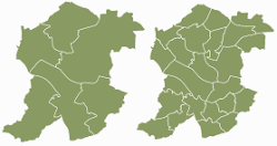
Sandwell Trends has been developed to make data about Sandwell available to everyone. The website contains a range of resources, reports and information which help to describe the borough and its population across a variety of topic areas and perspectives. There are critical pieces of work such as the Joint Strategic Needs Assessment, a series of ward & town profiles & a library of key publications. Please explore our key topics which give insight into Sandwell and its towns.
Sandwell is a metropolitan borough which was formed in 1974. The borough is named after the Sandwell Priory, and spans a densely populated part of the West Midlands conurbation. Sandwell comprises six towns - Oldbury, Rowley Regis, Smethwick, Tipton, Wednesbury and West Bromwich.
Sandwell's Strategic Town Centre is designated as West Bromwich, the largest town in the borough. Bordering Sandwell is the City of Birmingham to the east, the Metropolitan Borough of Dudley to the south and west, the Metropolitan Borough of Walsall to the north, and the City of Wolverhampton to the north-west. Spanning the borough are the parliamentary constituencies of West Bromwich West, West Bromwich East, Warley, and part of Halesowen and Rowley Regis, which crosses into the Dudley borough.


